 EMODnet Product Catalogue
Esri shapefile
Type of resources
Available actions
Topics
Keywords
Contact for the resource
Provided by
Years
Formats
Representation types
Update frequencies
status
Scale 1:
Resolution
-
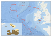
Multibeam echosounder data and seabed sampling data acquired during the INFOMAR national seabed mapping programme were the primary sources of data used in the generation of this habitat map for the Inshore Fisheries section of Bord Iascaigh Mhara. The original sediment classes assigned to the data were translated to the EUNIS habitat classification system as part of the MESH Atlantic project.
-
Targetted fishing ground for Nephrops norvegicus determined from Vessel Monitoring System data. The original classes assigned to the data were translated to the EUNIS habitat classification system as part of the MESH Atlantic project.
-

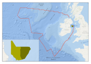
Data on marine habitats for the Irish Sea generated from the collation of historical sediment and biological data by Joint Nature Conservation Committee as part of the Irish Sea Pilot Project. The original classes assigned to the data were translated to the EUNIS habitat classification system as part of the MESH Atlantic project.
-
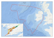
Multibeam echosounder data and seabed sampling data acquired during the 2011 MESH Atlantic survey were the primary sources of data used in the generation of this marine habitat map. Data on kinetic energy, derived from oceanographic models, and all of the interpreted survey data, were combined in a GIS environment and used to generate a EUNIS level 5 habitat map using the Maximum Likelihood Classification tool in ArcMap.
-

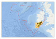
Multibeam echosounder data and seabed sampling data acquired during the INSS and INFOMAR national seabed mapping programmes were the primary sources of data used in the generation of this marine habitat map. The original classes assigned to the data were translated to the EUNIS habitat classification system as part of the MESH Atlantic project.
-

This classification was produced using approach similar to the used by BGS in creation of seabed sediments maps. The interpretation used data from surface grab samples and surface sub-samples from vibro core samples. Each sample was colour coded following detailed particle size analysis based on Folk classification. This data was incorporated within GIS and interpreted together with multibeam backscatter and shaded relief. This exercise allowed interpolation between areas where sample data was absent. Moreover, this interpretation was supported with video dive data. Thus, this study produced seabed sediment type facies interpretation for selected study areas that added more detail to the existing BGS maps. The original classes assigned to the data were translated to the EUNIS habitat classification system as part of the MESH Atlantic project.
-

Classification of Kenmare Bay into marine habitats. The original classes assigned to the data were translated to the EUNIS habitat classification system as part of the MESH Atlantic project.
-

Multibeam echosounder data and seabed sampling data acquired during the INFOMAR national seabed mapping programme were the primary sources of data used in the generation of this marine habitat map. The original classes assigned to the data were translated to the EUNIS habitat classification system as part of the MESH Atlantic project.
-

Classification of Roaringwater Bay into marine habitats. The original classes assigned to the data were translated to the EUNIS habitat classification system as part of the MESH Atlantic project.
-
Data on marine habitats for the Celtic Sea generated from the collation of historical habitat data by Aquafact Environmental Consultants as part of the Strategic Environmental Assessment of the Irish and Celtic Seas, and published in the IOSEA 4 Report. The original classes assigned to the data were translated to the EUNIS habitat classification system as part of the MESH Atlantic project.